Wednesday, October 27, 2010

Sending Thoughts and Prayers to Friends in Indonesia...


It's nice to see you again after a short break. I wanted to write a post today to pass along my best wishes to all the people in Indonesia in the wake of two catastrophic events, one imminent and the other potential. As we've learned from this blog, Indonesia is a very seismically active place because it sits on a subduction zone. The incredible forces within the Earth are manifested in earthquakes and volcanoes that frequently strike the archipelago.

Earlier this week an earthquake of magnitude 7.7 struck about 150 miles off the coast of Padang near the Mentawai islands. You may recall my mentioning both of these areas in previous posts. You may also recall that the city of Padang was struck by a large earthquake just over a year ago that did tremendous damage to the city. The most recent earthquake is a product of the subduction zone we've learned about. Many of these earthquakes are off-shore under the ocean, and there is always the possibility that a tsunami will be generated. Sunday's earthquake created a 3-meter (about 10 feet) tsunami. According to most recent reports, the death toll from the tsunami stands at 113 people. Hundreds of people are homeless as the tsunami struck low-lying fishing communities. Relief efforts are complicated because the Mentawai islands are somewhat isolated and hard to access. For up-to-date information in Indonesian check the Indonesian governments bureau of meteorology, climatology, and geophysics here. For up-to-date information in English check the USGS's site here.

At the same time, Gunung Merapi, Indonesia's most active volcano, is erupting. I also told you about Mt. Merapi in previous posts; it is the volcano close to Jogjakarta on the island of Java. The volcano has been expelling clouds of gas and ash every 5-10 minutes, sending deadly materials down its slopes. 13 people have been killed already. Indonesian officials have already said that this eruption is worse than the most recent eruption (2006), which killed 2 people. Fortunately, it is easier (though not easy) to predict volcanic eruptions than earthquakes, and Indonesian geologists have been warning about the eruption for a couple of weeks. Signs include inflated lava domes and landslides. When some volcanoes are getting ready to erupt, they actually swell up a little bit as they become filled with magma. Sometimes the pressure that builds up during this process is released slowly, but other times it causes an explosion, which can be devastating.

You can find information about how to help victims of these disasters at the blog linked to here. This site also features links to non-governmental organizations active in Indonesia. These organizations focus on relief and reconstruction. Let's all send our thoughts and prayers to the people that are affected by these events.

Update Oct 28: Friends at the US-Indonesia Society (www.usindo.org) suggest making donations to the following: Indonesian Red Cross: BCA Account No. 0353112233; Account name: Palang Merah Indonesia

Wednesday, October 6, 2010

Find Your Way to Make a Difference

Well, today is my last day in Indonesia for this trip. I fly back to Hawai'i via Seoul, South Korea tonight. It's been a good trip, and I am already excited about coming back at the beginning of next year. Today though I want to tell you about my friend Jakob, whom I met at Wisma Bahasa. He's been kind enough to let me stay at his apartment here in Jogja. Although Jakob is from Germany, he's traveled and studied all over the world. Now he's working for the German Development Corporation (GTZ) to help improve education here in Indonesia. But this is just his latest stop. Before moving to Jakarta Jakob started a company in Ecuador (1) with one of his buddies from graduate school. The company makes and sells leather bags. But it isn't just any company....Jakob's company gets their materials locally and their bags are produced by local skilled artisans. In addition to that, Jakob and his partner invest 25% of their proceeds in a foundation they started, which funds programs to help children that don't have an opportunity to go to school because they are so poor. I talked with Jakob a bit about his company. It's called "Longo". In the Quichua language used by indigenous people in Ecuador this word is used to describe a physically and mentally strong young person, but over the years the word has come to be used in a derogatory way to refer to anything indigenous, including people, habits, and customs. In Ecuador there are some people that think indigenous people and traditional ways of living are backwards and primitive. This is similar to the problem faced by the Mentawai people I told you about last time. But tradition and culture are very important; they are part of what makes people unique. Jakob and his partner believe that culture is nothing to be ashamed of, and I agree with them. You can find out more about Jakob's foundation here.

You can find your own special way to make a difference too. In this blog I've told you about problems, but I've also told you about possibilities and opportunities. I've told you about many special people out there that are working to make the world a better place. We've learned about Ming, who is helping to save bears, Agung who works to protect birds and educate people about the value of nature, and Luduwig, who works to make sure the community is safe. I've met lots of other people too. My good friends at Wisma Bahasa, for example, are not only working to teach people about language and culture, but they also have a lot of great outreach programs and are active in several communities. Then there are my new friends at the non-government organizations, Lembaga Tumbuh Alami, WARSI, and Floral and Fauna International, who are working to improve the environment and local livelihoods.

Start out by finding out about the world. Open your eyes, because there is a lot of wonderous stuff to see out there. I've gone from the mega-city of Jakarta to the cultural heartland of Jogja to the forests and hills of Sumatra, but I've only just begun to see this beautiful country. You can chart your own course too....be an explorer.

Along the way you'll meet great people. For me there have been so many new and old friends on this trip. There's Roro, Isna, Yos Hengke, Agus, Butet, Itha, Prisca, Nurze, Kanya, and many others at Wisma Bahasa. There's also Zoe at FFI, Emma and Hamdani at LTA, and Rainal and the folks at WARSI. At Kerinci Seblat National Park I was lucky to meet Pak Naj, Yohan and Andhikata. Other friends have helped me and hosted me, like Agung, Jakob and Eleo, and John.

I'll be back here again soon, and I'll keep my blog updated, so be sure to check back. That's it for now...next time you see me I'll be surfing!

1) Can you find Ecuador on a map? Where do you think the name of the country comes from?

Tuesday, October 5, 2010

Dulce Et Decorum Est...Jakarta Style

Well my young friends, I'm back in Jakarta. I'm having a hard time typing because my gas mask keeps getting in the way. My faithful laptop is about to give up the ghost, as they say, from the fumes. Let's hope it can make it back to Hawai'i so he can be laid to rest in the land that begat him.

Yesterday I had I a nice trip over from Padang. In the morning I was able to visit KKI-WARSI, a non-governmental organization active in the areas around Kerinci Seblat National park. The KKI in KKI-WARSI stands for Komunitas Konservasi Indonesia, or Community Conservation Indonesia. WARSI is a great group of people that is working to protect forests of Indonesia by helping the people that live around the forests. They feel that one of the biggest reasons that people cut down trees is because they are so poor that they are forced to. So WARSI works to improve livelihoods and access to job opportunities. You can check out their website at http://www.warsi.or.id/. It's in Indonesian, though.

I also had a pleasant surprise on the airplane....just as I was about to board the ticket clerk found me and gave me a new boarding pass. I had been bumped up to business class! As you amble your way down life's winding path, you'll find that there are few things in life better than being bumped up to business class. Sure, you might win the lottery and all-you-can eat ice cream bars are cool, but getting moved up to the exclusive universe of limitless legroom and free drinks is pretty much the big-rock-candy-mountain of the air. I guess the folks at Lion Air read my previous blog post and were flattered at all the nice things I said about them and the free publicity. Too bad the flight was only an hour and a half. I took a picture of the seat so you can compare and contrast with the regular seat from a few posts ago.

Before I left Padang I walked around the city a bit. They have a nice black-sand beach there, but there aren't very many waves for surfing because there is another chain of islands, the Mentawais, a few miles off shore. The Mentawais are famous for a number of reasons. They have some of the best surf breaks in the world, and surfers come from far and wide for the waves. But also the Mentawais are home to a very distinctive people with a unique culture. The Mentawai people are semi-nomadic hunter-gatherers. They live in the rain forest, which provides food, medicine, and other materials to meet daily needs. The Mentawai people live in traditional dwellings called uma. These are multi-family structures made of wood, grass, and bamboo. Although the Mentawai culture is unique and fascinating, it is under pressure from outside. Missionaries have tried to convert the Mentawai to Christianity and Islam. And the government has tried to change their lifestyle so the people are more "modern". The Mentawai have been resistant to change so they can preserve their traditional lifestyle and culture, but change is evident. Native Hawaiians have faced similar problems in the past. In fact, Hula and surfing were both outlawed fir a time because they were seen as sacrilegious. Now these two things are part of the Hawaiian identity. Can you imagine life without them? The point here is that cultural differences are sometimes used to discriminate against people or belittle a certain group. It's only until later that we recognize how unique and interesting cultures are. I'll tell you about a related story tomorrow.

I also noticed a good bit of earthquake damage in Padang. Just about a year ago the city suffered a devastating earthquake measuring 7.4 on the Richter scale. It hit close to town and killed an estimated 5000 people. I've included a couple of pictures so you can see what an earthquake like that can do to a building. The damage was so devastating in part because the proximity of the quake, but the construction techniques used in Indonesia (and in many other countries) also contribute to the damage and death toll. You can see from the rebuilding picture that I've included that bricks are used extensively in construction here. If too much mortar is used between the bricks, the structures get weaker, especially against earthquakes.

Today I did some work and then walked around Jakarta until I got tired of wheeling around my Personal Breathing Apparatus (PBA). Jakarta is a giant city. It's so big that Geographers have a special name for it...we call it (and other cities like it) a megacity. Sounds pretty neat, eh? But Jakarta has a lot of problems. There are so many people here that the city government is not able to provide essential services to everyone. But people keep coming, hundreds every day. They come from other places around the country looking for opportunities. Because of a lack of housing, people have built shanties along canals, under highway bridges, and along railroad tracks. In addition, there are so many cars that the there is a semi-permanent haze over the city.

Saturday, October 2, 2010

What Makes the Tropics So Tropical?

By now you've seen me use the term "tropical" a number of times. This word is used pretty frequently...we talk about tropical weather, tropical drinks, tropical storms, and tropical diseases (YIKES!). But for Geographers the term "tropical" has a very simple meaning. It refers to the part of the globe that is between 23.5 degrees south and 23.5 degrees north of the equator (1). The equator is the imaginary line that runs east-west around the planet, like a belt. The northern boundary at 23.5 degrees north latitude is called the Tropic of Cancer, and the southern boundary at 23.5 degrees south latitude is the Tropic of Capricorn. If you have a hard time remembering this, you can tell yourself that Capricorn has more letters than Cancer, so it's heavier and therefore sinks. One important thing about the tropics is that there isn't much season variation there; there are not big differences between summer and winter. You know this from living in Hawai'i. Indonesia is like this too.

Anyway, this region is really important for a number of reasons. The tropics is the only place you can find the sun directly overhead. In 
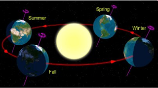
Hawai'i (2) this happens twice a year. This has to do with the relationship between the Earth and the sun. Let me explain. Look at the diagram to the right. This is a simple picture of the Earth and sun. Notice that the Earth is tilted in relation to the sun. You can see this on almost any globe you look at. This tilt is very important for the seasons; if there was no tilt there wouldn't be any summer, spring, winter or fall! Also notice in the diagram that the tilt is always in the same direction relative to the sun. We call this "axial parallelism". The tilt of the Earth and the direction of the tilt don't change over the course of a human lifetime (3). Now as you can see from the second diagram, this means that different parts of the Earth have more or less exposure depending on their latitude, or how far north or south of the equator they are. This affects how long the day is. Think about it this way. We all know that one day has 24 hours, right? Wherever you go on the planet, even Indonesia, even the North Pole, one day lasts 24 hours. That means the Earth spins on its axis one time in 24 hours. Since you are standing on the Earth that means it takes you 24 hours to go around in a big circle. But the size of that circle depends on where you are standing on the Earth. You can see two circles on the second diagram. One is big and one is small. This means that the surface of the Earth is spinning faster at the big circle than at the small circle. If you are riding on the bigger circle, you cover a greater distance in the same amount of time. That's not all. As you can tell from the circle, different parts of the Earth get different amounts of sunlight. This is due to the tilt.

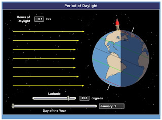
Now let me use some still shots I took from one of the models I used when I teach about this to show you what this means for seasons. In the first three pictures you notice the northern part of the Earth is tilted towards the sun. You should be able to locate several lines on the pictures. Which lines have the longest sections in the daylight? That's right, the ones towards the top. We already said that this means the days are longer. To illustrate the point, have a look at the Geography Giant standing on the globe. You can tell from the different pictures that when he stands closer to the North Pole, the day is longer (about 20 hours!). However, the day is really short when he's close to the South Pole (about 5 and a half hours). This is a huge difference. But when he stands on the Equator, the day is 12 hours long (and night is 12 hours too). Now we've already learned that all energy comes from the sun. The sun also makes things hot! So it makes sense that the longer the sun is out, the warmer it is. What season do you think it is in the northern part of the planet? How about the southern part?

Now let's 
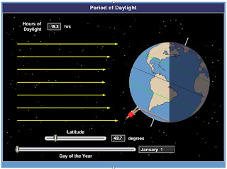
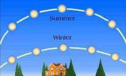
turn the situation around and think about what happens when the Earth is tilted the other way relative to the sun. Remember what I said about the lines in the last section? Let's try that again. Which lines are longer? So where are the days longer? That's right, closer to the South Pole. When the Geography Giant stands near the North Pole, the day is short (5 hours), but when he moves near the South Pole the day is much longer (19 hours)! That's a big difference from what we just saw! Now notice how long the day is when the Geography Giant stands at the Equator...it's still 12 hours! So this shows us why there are seasons....it's because the day length, and hence the amount of energy from the sun, changes quite a bit over the course of the year. And it also tells us why there is not much seasonal variation near the tropics: because the days are almost the same length all year round, and so there is a pretty constant level of energy from the sun. In fact, because the sun always passes high in the sky in the tropics, there is a lot of energy. Not only does this energy make it warm, it also helps to evaporate a lot of water (and drive the ITCZ, remember?), which leads to lots of rain in some places. In addition, since plants like sunlight so much, there is a lot of it so lots and lots of plants can grow. The sun doesn't pass as high in the sky outside the tropics. The height also changes with the seasons. You can see an example in the picture to the left. The lower the sun is in the sky, the more of its energy is bounced off the Earth into space, making it still colder in the winter time! I'll let you think about this for a while. It might help you to use a globe. When you feel like you've got it down, try the questions I've included below.

1) "Latitude" refers to how far north or south of the equator a location is. Geographers use a special grid, called the Geographic Coordinate System, to describe places on the Earth's surface. Using just two numbers, the latitude and the "longitude" (this describes how far east or west of the Prime Meridian you are, we can give precise information about the location of anything! Can you find out the coordinates for Honolulu? How about Sungai Penuh?

2) Hawai'i is in the tropics. How can you tell this from the information you just obtained about its coordinates?

3) The tilt of the Earth and its direction do change, but these happen on cycles of about 41,000 and 26,000 years, respectively.

Friday, October 1, 2010

A Day in the Life of Sungai Penuh

I woke up, fell out of bed, and dragged the comb across my head. Found my way off the floor and had a cup, and looking up, I noticed I was late. I found my backpack and grabbed my clean shirt and made the ojek in seconds flat. This is Sungai Penuh. I'm not quite sure how many people live here, but this the regional hub for Kerinci Valley. It's a nice and quiet town and the scenery is nice. It's very distinctive because it is still relatively untouched by big-city influences. One big thing has changed since the last time I was here, though...they have the internet now. And although it's slow, it's everywhere. There are little internet stores all over town, more than I've ever seen in such a small area. And usually they are full. I have developed a theory about this...I believe that the rapid spread of the internet to remoter parts of Indonesia is due to one factor above all others: Facebook. Everyone here does Facebook; in fact, Indonesia has the second-most Facebook users on the planet.

There are two ways to get around in Sungai Penuh (besides walking, of course). One is called ojek. Ojek drivers are people that have a motorcycle and will take you where you want to go for 2000 rupiah, which is about 25 cents. They are everywhere and so this is a convenient way to get around. You can see one of the ojek posts in the picture I've included. I like the sign for this one. The second way is by bendi, or horse cart. This was is a bit slower, but it's also more colorful (and sometimes smelly). It doesn't take that long to get any place because the town is relatively small. Most of the time I just walk, but since it rains about every day the ojeks and bendis come in handy. Everyone is very friendly here, and I hear "Hello Mister!" about a thousand times a day. Since there are not many foreigners through Sungai Penuh there is always someone that is eager to talk for a while. I had a nice conversation with the guys in the picture below. Believe it or not, that scooter thing they are sitting on actually runs. I call this guy the "Ayatollah of Rock and Rollah".

Today was Friday, which is the holy day for Muslims. On Fridays Muslims go to the mosque at around noon for Friday prayers. I estimate 95% of the population of this town to be Muslims, and so the streets were very lively today in the early afternoon. Most government offices shut down at noon on Friday so the workers can go to the mosque, and so today I got kicked out of the park office at 12. I walked around the town a bit and took some pictures. To the right you can see rice drying in the street. Remember I told you that this is an agricultural area, and so many of the people living in Sungai Penuh are farmers. Then I went to the market to buy a present for my friend Agung because he's been nice enough to let me stay at his place while I'm here. Then I went home, worked on my reports a bit and took a nap. I've been pleased with how much work I've been able to accomplish here. Everyone has been very helpful, and a local non-governmental-organization (NGO) has agreed to be my partner for my research. This is very important in Indonesia because it helps in obtaining the visas and research permits that are required to work here. It's also good to have a local partner because they know all about this area along with the problems and opportunities. The organization I am going to be working with when I come back here is called Lembaga Tumbuh Alami. They have a lot of great projects to help the villagers living around the park so the villagers don't have to be so dependent on resources in the park for their livelihoods. They help with economic development and also with alternative energy sources, so villagers don't have to use so much wood to cook.

In the evening there is not much to do in Sungai Penuh. Last night I rented a couple of movies. Tonight I don't have many plans. One of the big events is taking a "shower". You can see the bathroom in the picture I've included. That big concrete container is called a "bak mandi". I fill it with water that I use to flush the toilet, wash clothes, and get clean. The little green dipper is what I use to pour the water over myself. Now, you might notice that there is only one pipe coming out of the wall. That's because the water here comes at one temperature, and it ain't warm. I would go so far as to call it "bone-chillingly cold". But water is water, and it does the trick. It has the added benefit of really waking me up.

That's about it for today. Tomorrow is my last full day in Sungai Penuh; after that I take the long ride back to Padang, and then back to Jakarta. I am going to try to have some more meetings in both of those places, but for the most part my work for this trip is almost done. I've learned a great deal, but the best thing for me is that I realize that my research project is important for the people here, including those that work for the park and those that are in conflict with the park. For a researcher that's a really exciting prospect.