 By now you've seen me use the term "tropical" a number of times. This word is used pretty frequently...we talk about tropical weather, tropical drinks, tropical storms, and tropical diseases (YIKES!). But for Geographers the term "tropical" has a very simple meaning. It refers to the part of the globe that is between 23.5 degrees south and 23.5 degrees north of the equator (1). The equator is the imaginary line that runs east-west around the planet, like a belt. The northern boundary at 23.5 degrees north latitude is called the Tropic of Cancer, and the southern boundary at 23.5 degrees south latitude is the Tropic of Capricorn. If you have a hard time remembering this, you can tell yourself that Capricorn has more letters than Cancer, so it's heavier and therefore sinks. One important thing about the tropics is that there isn't much season variation there; there are not big differences between summer and winter. You know this from living in Hawai'i. Indonesia is like this too.
Anyway, this region is really important for a
 number of reasons. The tropics is the only place you can find the sun directly overhead. In
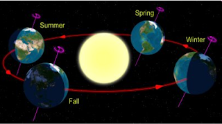
  Hawai'i (2) this happens twice a year. This has to do with the relationship between the Earth and the sun. Let me explain. Look at the diagram to the right. This is a simple picture of the Earth and sun. Notice that the Earth is tilted in relation to the sun. You can see this on almost any globe you look at. This tilt is very important for the seasons; if there was no tilt there wouldn't be any summer, spring, winter or fall! Also notice in the diagram that the tilt is always in the same direction relative to the sun. We call this "axial parallelism". The tilt of the Earth and the direction of the tilt don't change over the course of a human lifetime (3). Now as you can see from the second diagram, this means that different parts of the Earth have more or less exposure depending on their latitude, or how far north or south of the equator they are. This affects how long the day is. Think about it this way. We all know that one day has 24 hours, right? Wherever you go on the planet, even Indonesia, even the North Pole, one day lasts 24 hours. That means the Earth spins on its axis one time in 24 hours. Since you are standing on the Earth that means it takes you 24 hours to go around in a big circle. But the size of that circle depends on where you are standing on the Earth. You can
 see two circles on the second diagram. One is big and one is small. This means that the
  surface of the Earth is spinning faster at the big
  circle than at the small circle. If you are riding on the bigger circle, you cover a greater distance in the same amount of time. That's not all. As you can tell from the circle, different parts of the Earth get different amounts of sunlight. This is due to the tilt.
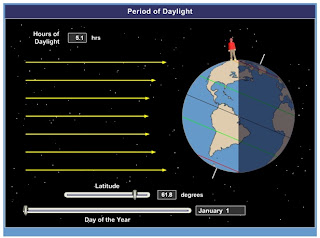
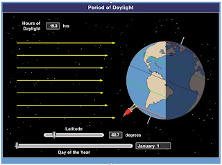
Now let me use some still shots I took from one of the models I used when I teach about this to show you what this means for seasons. In the first three pictures you notice the northern part of the Earth is tilted towards the sun. You should be able to locate several lines on the pictures. Which lines have the longest sections in the daylight? That's right, the ones towards the top. We already said that this means the days are longer. To illustrate the point, have a look at the Geography Giant standing on the globe. You can tell from the different pictures that when he stands closer to the North Pole, the day is longer (about 20 hours!). However, the day is really short when he's close to the South Pole (about 5 and a half hours). This is a huge difference. But when he stands on the Equator, the day is 12 hours long (and night is 12 hours too). Now we've already learned that all energy comes from the sun. The sun also makes things hot! So it makes sense that the longer the sun is out, the warmer it is. What season do you think it is in the northern part of the planet? How about the southern part?
Now let's


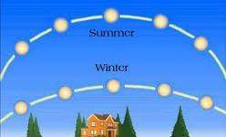
 turn the situation around and think about what happens when the Earth is tilted the other way relative to the sun. Remember what I said about the lines in the last section? Let's try that again. Which lines are longer? So where are the days longer? That's right, closer to the South Pole. When the Geography Giant stands near the North Pole, the day is short (5 hours), but when he moves near the South Pole the day is much longer (19 hours)! That's a big difference from what we just saw! Now notice how long the day is when the Geography Giant stands at the Equator...it's still 12 hours! So this shows us why there are seasons....it's because the day length, and hence the amount of energy from the sun, changes quite a bit over the course of the year. And it also tells us why there is not much seasonal variation near the tropics: because the days are almost the same length all year round, and so there is a pretty constant level of energy from the sun. In fact, because the sun always passes high in the sky in the tropics, there is a lot of energy. Not only does this energy make it warm, it also helps to evaporate a lot of water (and drive the ITCZ, remember?), which leads to lots of rain in some places. In addition, since plants like sunlight so much, there is a lot of it so lots and lots of plants can grow. The sun doesn't pass as high in the sky outside the tropics. The height also changes with the seasons. You can see an example in the picture to the left. The lower the sun is in the sky, the more of its energy is bounced off the Earth into space, making it still colder in the winter time! I'll let you think about this for a while. It might h
 elp you to use a globe. When you feel like you've got it down, try the questions I've included below.
1) "Latitude" refers to how far north or south of the equator a location is. Geographers use a special grid, called the Geographic Coordinate System, to describe places on the Earth's surface. Using just two numbers, the latitude and the "longitude" (this describes how far east or west of the Prime Meridian you are, we can give precise information about the location of anything! Can you find out the coordinates for Honolulu? How about Sungai Penuh?
2) Hawai'i is in the tropics. How can you tell this from the information you just obtained about its coordinates?
3) The tilt of the Earth and its direction do change, but these happen on cycles of about 41,000 and 26,000 years, respectively.
No comments:
Post a Comment