 |
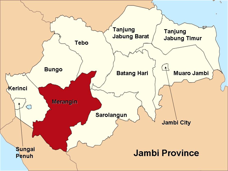
| Map from here. Note Jambi Province |
This week I'm down in Bangko, the capital of Merangin district for some research work. Merangin is just east of Kerinci district, where I live. It's one of the districts of Jambi province, which you can see from the map to the left. One of the things I'm interested in is the long- and mid-range planning documents from the regional planning authority (BAPPEDA). These documents have all sorts of information about the socio-economic aspects of the district, as well as information concerning the policy orientation of the government (i.e. what are the problems facing the district and what are the steps the government needs to take to address the problem). Knowing these aspects of the district, which has about 20% of its territory covered by Kerinci Seblat National Park, helps me to understand the roots and context of current and potential conflicts between the people and institutions in the district and the park. And, as a geographer, I like to look at the plans because they have all sorts of cool maps.
One section of the district's long-term (15 year) development plan describes the hierarchy of cities in the district. As I read through the description, I was reminded of one of the classic models of geography: Walter Christaller's Central Place Theory.
Central Place Theory
 |
| Awesome GIF from Wikipedia |
Walter Christaller was a German geographer active from the 1920s until around the 1950s(1). He is most known for his Central Place Theory, which is a staple of introductory geography textbooks. Central place theory is a model that attempts to describe
(and predict) where and why cities of different sizes will be found on the
landscape, and how they relate to one another.
The model has some basic assumptions, like most simple geographic models
(recall my explanation of Von Thunen's model in a previous post). It assumes that the world is an isotropic
plain and that resources and people are distributed equally. All people make rational decisions, and they
will go to the closest place offering the goods or services they need. Since the landscape is an isotropic plane,
they can take the shortest distance to their destination.
Christaller divided goods and services into different
categories. Simple or lower order
services include things like markets and gas station and can be found in a lot
of locations. More specialized or higher order services like universities are
fewer and farther between. Directly
related to the order of service are two concepts which Christaller pioneered:
threshold and range. Threshold refers to
the minimum population required to support a certain type of service. Think about a minimarket, for instance. They are everywhere because it doesn't take
too many customers to keep a minimarket in business. The threshold is low. Range, on the other hand, is the maximum
distance people are willing to travel to avail themselves of a service. Returning to our minimarket example, you're probably
not willing to travel too far to find a Circle K. So the range is low as well. However, there are some services, like movie
theaters, ice skating rinks, Ikeas, etc, that you are willing to travel farther
to access. At the same time, these
services need a lot more folks to keep them in business. So the threshold and range are both high. Cities or towns that provide only simple
services are low order settlements, whereas larger cities that offer a more
comprehensive range of services are high order settlements.
 |
| Diagram from Hofstra University's excellent website. |
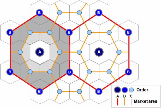
Christaller's basic idea is that in a given region, there will only be a few high-order settlements, but there will be lots of lower-order ones. What's more, settlements will be spaced equidistant from one another, and higher-order settlements will be surrounding by a number of lower order settlements, which rely on the bigger city for rarer goods and services. There are several levels in the hierarchy, from huge metropolises on down to regional cities, towns, villages and hamlets. You can see a diagram of the arrangement of the various classes of settlement to the right. Each of the different types of settlement has a different market area; large (higher order) cities have bigger market areas. Remember that people will go to the place closest to them offering the desired good or service; this accounts for the regular spacing (2). In addition to this market principle (known in the theory as the k-3 principle) Christaller also described transportation (k-4) and administrative (k-7) functions, but we don't need to go into those here.
Christaller used Central Place Theory in his role as a planner for several evil regimes in Europe. Since the introduction of his theory, scholars in geography have attempted to apply it to other instances as well in order to prove or disprove its merits. It has also influenced the discipline of regional planning, as we'll see below.
Central Place and Merangin District?
The capital of Merangin district is Bangko. Bangko is surrounded by a number of smaller towns, which in turn are surrounded by villages. The district is mainly agricultural but there is some industry as well (most of which centers on the processing of agricultural commodities). As you can imagine, there is a natural ranking of services in the settlements of various size in Merangin. For instance, every village has a place to buy instant noodles or cell-phone credit. Larger towns act as transportation hubs, and the capital city functions as an administrative, management, and financial center. That's all common sense, and in my mind Christaller doesn't deserve much credit for describing the natural way that markets work.

In order to facilitate this vision, the planners have created a hierarchy much like Christaller's. In the district system Bangko, the capital, is referred to as an Order 1 (Orde 1) center. It is a center of transportation, located on the main overland route to the provincial capital at Jambi as well as the roads to other districts (Sarolangun, Bungo, and Kerinci). It has the most complete economic facilities and is also a center of banking, trade, management, and communication. In the words of the planning document, it is the Center of Regional Activities (Pusat Kegiatan Wilayah, PKW). Beneath Bangko in Kota Rantau Panjang, the capital of Tabir subdistrict. Rantau Panjang is an Order 2 (Orde 2) town in the district framework and is a center of local activities (Pusat Kegiatan Lokal, PKL). It has good infrastructure and provides subregional services. Then at Order 3 (Orde 3) we have Sungai Manau and Pamenang. Both of these towns are about equidistant from Bangko. In the planning framework they provide lower-order services to their hinterlands and are supposed to spur development in the areas immediately around them. Lastly we find Muara Siau, a smaller town at Order 4 (Orde 4). The quality of infrastructure is lower, and it provides still lower-order services to the mainly agricultural hinterlands surrounding it.
The planners of Merangin district use this framework to help plan what sorts of projects need to be developed in various places. For example, they are working to develop higher-order transport facilities in the district capital, but in the lower-order centers they plan smaller-scale projects aimed at improving specific aspects of the economy in those places. This helps them to distribute resources, like money and equipment, in a more efficient manner aimed at developing the district as a whole. You can see the results in the map below, which divides the entire district into development zones, each with its own set of projects and targets. I've labeled the various centers along with their order. The spatial arrangement somewhat mirrors that predicted by Christaller, but more important, at least to me, is the function of the various centers.
The planners of Merangin district use this framework to help plan what sorts of projects need to be developed in various places. For example, they are working to develop higher-order transport facilities in the district capital, but in the lower-order centers they plan smaller-scale projects aimed at improving specific aspects of the economy in those places. This helps them to distribute resources, like money and equipment, in a more efficient manner aimed at developing the district as a whole. You can see the results in the map below, which divides the entire district into development zones, each with its own set of projects and targets. I've labeled the various centers along with their order. The spatial arrangement somewhat mirrors that predicted by Christaller, but more important, at least to me, is the function of the various centers.

We can see from this example that geographic models not only help us understand spatial distribution and organization from a theoretical perspective, but they are also important tools in policy making. Central Place Theory has clearly influenced the planners in Merangin district and has helped them to formulate a development plan that specifically addresses the strengths and weaknesses of each subdistrict.
(1) Christaller was not only a NAZI, but a COMMUNIST as well. I faced something of a moral dilemma when writing this post....I am still somewhat ambivalent about describing a theory that was used primarily for organizing hostile occupations and oppression
(2) Christaller adopted hexagons rather than circles because hexagons nest together perfectly without any overlap or gaps, unlike circles.
(3) I am basing this on the 2006 long-range plan; in 2008-9 the authorities experienced a frenzy of new district creation, and now there are 26 kecamatans.
No comments:
Post a Comment